Kilauea Volcano, Hawaii.

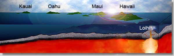
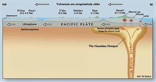
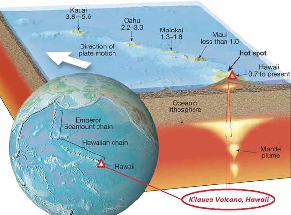
Kilauea is a currently active shield volcano in the Hawaiian Islands, and the most active of the five Hawaiian volcanoes. Kilauea is the most active volcano on the Earth. Located along the southern shore of the island. Coordinates: 19°25’16″N; 155°17’13″W, Summit Elevation: 1247 m. Kilauea’s current eruption dates back to January 3, 1983, and is by far its longest-lived historical period of activity, as well as one of the longest-lived eruptions in the world; as of January 2011, the eruption has produced 3.5 cubic kilometers of lava and resurfaced 123.2 km2 of land. Volcano Kilauea is between 300,000 and 600,000 years old. Volcano emerged above sea level about 100,000 years ago. It is the second youngest product of the Hawaiian hotspot and the current eruptive center of the Hawaiian–Emperor seamount chain. Structurally, Kilauea has a large, fairly recently formed caldera at its summit and two active rift zones, one extending 125 km east and the other 35 km west, as an active fault line of unknown depth moving vertically an average of 2 to 20 mm per year.

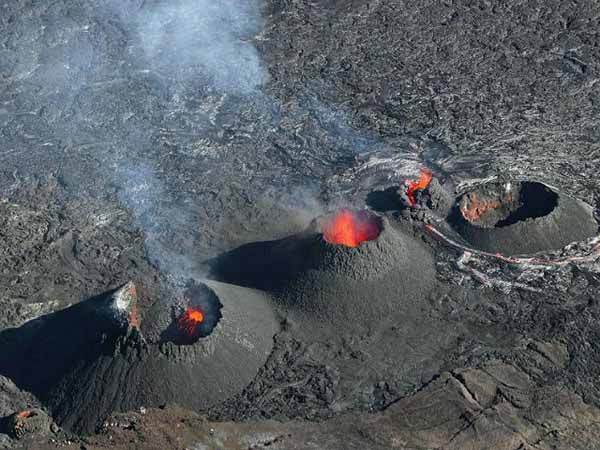
Hawaii Kilauea Volcano Eruption&Lava Flow. Video.

Loihi Volcano (Seamount). Hawaii.

Loihi Seamount is an active submarine volcano built on the seafloor south of Kilauea about 35 km from the Hawaii Island. The seamount rises to 969 m below sea level. Loihi is the newest volcano in the Hawaiian-Emperor seamount chain, a string of volcanoes that stretches over 5,800 km northwest of this volcano.
Location: 18.92 N 155.27 W.
Volume: 660 km3.
Like the volcanoes on the Island of Hawaii, Loihi has grown from eruptions along its 31-km-long rift zone that extends northwest and southeast of the caldera.

Loihi volcano (Seamount). Video.


Mauna Loa Volcano, Hawaii.

Mauna Loa volcano is one of five volcanoes that form the Island of Hawaii in the Pacific Ocean. Mauna Loa has is the world’s largest subaerial, its most active giant shield volcano.
Location: 19.475 N 155.608 W.
Elevation above sea level: 4,170 m.
Area: 5,271 km2 (50.5% of Hawaii island)
Volume: 80,000 km3.

Hawaii Mauna Loa Volcano Eruption&Lava Flow. Video.


Impressive Piton de la Fournaise volcano Eruption. Reunion Hotspot.

The origin of the Reunion Island is commonly attributed to a mantle hotspot. According to certain scientists, this hotspot first created the Deccan Traps, a large basalt province in India, about 65 million years ago. Its trace corresponds to Chagos-Lacadive Ridge, Mascarene Plateau, and Mauritius Island (created between 18 and 28 million years ago). Reunion became active about 5 million years ago, reaching the surface about 2 million years ago, and is the youngest island originating from this hotspot.

Piton de la Fournaise is a basaltic shield volcano on the eastern side of Reunion Island in the Indian Ocean. Piton de la Fournaise is one of the most active and the biggest volcanoes on Earth, along with Kilauea in the Hawaiian Islands (Pacific Ocean), Stromboli, Etna (Italy) and Mount Erebus in Antarctica. From the ocean floor, it is over 6,600 m tall. The base of the volcano has a diameter of 220 km.
Location: 21.23 S; 55.71 E.
Elevation: 2,631 m.
The Enclos Fouque, a caldera 8 kilometers wide, occupies the top part of the volcano. High cliffs known as remparts form the caldera’s rim. The caldera is breached to the southeast into the sea. It is unstable and is in the initial stages of failure. It will eventually collapse into the Indian Ocean to form giant landslides like those in Hawaii.
Three calderas formed at about 250,000, 65,000, and less than 5000 years ago by progressive eastward slumping of the volcano. Numerous pyroclastic cones dot the floor of the calderas and their outer flanks.


3D Model Of Yellowstone Hotspot and Plume

The Yellowstone plume has been tomographically imaged as a tilted body extending from 80 km depth at the Yellowstone Plateau to 660 km depth beneath western Montana. Geodynamic modeling of the plume finds that the plume is up to 120 K hotter than the surrounding mantle, with a maximum of 2.5% melt and a small buoyancy flux of 0.25 MG/s, properties of a cool, weak plume. Mantle flow modeling is used to constrain the evolution of the hotspot: the Yellowstone plume initially ascended vertically through the mantle beneath the thin, accreted lithosphere of the Columbia Plateau and was responsible for the 17 Ma flood basalts there. At 12 Ma, the plume passed beneath the thicker North American lithosphere and became entrained in eastward upper mantle return flow, resulting in a shift of volcanic activity to the southeast and the onset of rhyolitic eruptions caused by melting in the lithosphere. As the North America plate moved southwest, hotspot volcanism propagated northeast, and the resulting tectonic and magmatic interactions produced the 700-km-long Yellowstone-Snake River Plain magmatic system.


Credit:
University of Utah Seismology and Active Tectonics Research Group