KILAUEA VOLCANO 19°25’16” N 155°17’13” W, Summit Elevation 4091 ft (1247 m)
Activity Summary: Kilauea Volcano continues to erupt at its summit and East Rift Zone. Lava continues to enter the ocean at Kamokuna and surface flows remain active within 2.4 km (1.5 mi) of the vent at Puʻu ʻŌʻō. These lava flows currently pose no threat to nearby communities. At the summit, DI deflationary tilt continued and the lava lake surface dropped to about 38 m (125 ft) below the floor of Halemaʻumaʻu crater this morning.
Summit Observations: Summit tiltmeters recorded continuing DI deflation. The lava lake surface dropped along with the tilt and is estimated to be about 38 m (125 ft) below the floor of Halemaʻumaʻu crater this morning. Seismicity rates were at background levels and tremor values fluctuated in response to changing lava lake circulation, spattering, and rockfalls. Sulfur dioxide emission rates ranged from about 4,600 to 5,800 metric tons/day over the past week, when measurements were possible during trade wind conditions.
Category: Hawaii hotspot
Kilauea Volcano, Hawaii.
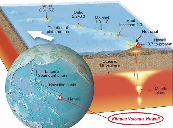
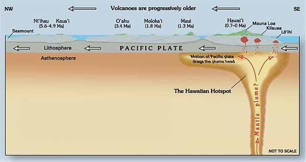
Kilauea is a currently active shield volcano in the Hawaiian Islands, and the most active of the five Hawaiian volcanoes. Kilauea is the most active volcano on the Earth. Located along the southern shore of the island. Coordinates: 19°25’16″N; 155°17’13″W, Summit Elevation: 1247 m. Kilauea’s current eruption dates back to January 3, 1983, and is by far its longest-lived historical period of activity, as well as one of the longest-lived eruptions in the world; as of January 2011, the eruption has produced 3.5 cubic kilometers of lava and resurfaced 123.2 km2 of land. Volcano Kilauea is between 300,000 and 600,000 years old. Volcano emerged above sea level about 100,000 years ago. It is the second youngest product of the Hawaiian hotspot and the current eruptive center of the Hawaiian–Emperor seamount chain. Structurally, Kilauea has a large, fairly recently formed caldera at its summit and two active rift zones, one extending 125 km east and the other 35 km west, as an active fault line of unknown depth moving vertically an average of 2 to 20 mm per year.
Hawaii Kilauea Volcano Eruption&Lava Flow. Video.
Loihi Volcano (Seamount). Hawaii.
Loihi Seamount is an active submarine volcano built on the seafloor south of Kilauea about 35 km from the Hawaii Island. The seamount rises to 969 m below sea level. Loihi is the newest volcano in the Hawaiian-Emperor seamount chain, a string of volcanoes that stretches over 5,800 km northwest of this volcano.
Location: 18.92 N 155.27 W.
Volume: 660 km3.
Like the volcanoes on the Island of Hawaii, Loihi has grown from eruptions along its 31-km-long rift zone that extends northwest and southeast of the caldera.
Loihi volcano (Seamount). Video.
Mauna Loa Volcano, Hawaii.
Mauna Loa volcano is one of five volcanoes that form the Island of Hawaii in the Pacific Ocean. Mauna Loa has is the world’s largest subaerial, its most active giant shield volcano.
Location: 19.475 N 155.608 W.
Elevation above sea level: 4,170 m.
Area: 5,271 km2 (50.5% of Hawaii island)
Volume: 80,000 km3.
Hawaii Mauna Loa Volcano Eruption&Lava Flow. Video.


