Kilauea Volcano eruptions 2017

KILAUEA VOLCANO 19°25’16” N 155°17’13” W, Summit Elevation 4091 ft (1247 m)
Activity Summary: Kilauea Volcano continues to erupt at its summit and East Rift Zone. Lava continues to enter the ocean at Kamokuna and surface flows remain active within 2.4 km (1.5 mi) of the vent at Puʻu ʻŌʻō. These lava flows currently pose no threat to nearby communities. At the summit, DI deflationary tilt continued and the lava lake surface dropped to about 38 m (125 ft) below the floor of Halemaʻumaʻu crater this morning.
Summit Observations: Summit tiltmeters recorded continuing DI deflation. The lava lake surface dropped along with the tilt and is estimated to be about 38 m (125 ft) below the floor of Halemaʻumaʻu crater this morning. Seismicity rates were at background levels and tremor values fluctuated in response to changing lava lake circulation, spattering, and rockfalls. Sulfur dioxide emission rates ranged from about 4,600 to 5,800 metric tons/day over the past week, when measurements were possible during trade wind conditions.

Cerro Azul VolcanoEruption. Galapagos Islands. 2008

Shield volcano 1640 m / 5,381 ft
Isabela Island, Galapagos Islands (Ecuador), -0.92°S / -91.41°W
Cerro Azul volcano eruptions: 1850, 1932, 1940, 1943, 1948, 1949(?), 1951, 1959, 1968(?), 1979, 1998, 2008

Cerro Azul volcano a basaltic shield volcano on the SW part of Isabela Island in the Galápagos Islands. It has the same name as Cerro Azul volcano in Chile, meaning “Blue Mountain” in Spanish.
Cerro Azul is one of the most active volcanoes of the Galapagos hot spot.

Cerro Azul, 1640 m high and the second highest peak of the Galápagos archipelago, is a typical shield volcano located at the SW tip of Isabela Island. It is one of the most active volcanoes of the Galapagos, although historic records from its activity only dates back to 1932.
As most of the other shield volcanoes on the Galapagos island, it has a steep-walled 4 x 5 km nested summit caldera, one of the smallest diameter, but at 650 m one of the deepest in the Galápagos Islands. Young lava lows cover most of the floor of the caldera, where temporary lava lakes are sometimes present during summit eruptions. Numerous spatter cones from lateral fissure eruptions dot the western flanks of the volcano.

Fernandina Volcano Eruption. Galapagos Islands. 2009.

Shield volcano 1476 m / 4,842 ft
Galápagos Islands, Ecuador, -0.37°S / -91.55°W

Fernandina volcano eruptions: 2009

Fernandina, the most active of Galápagos volcanoes and the one closest to the Galápagos mantle plume, is a basaltic shield volcano with a deep 5 x 6.5 km summit caldera. The volcano displays the classic “overturned soup bowl” profile of Galápagos shield volcanoes. Its caldera is elongated in a NW-SE direction and formed during several episodes of collapse. Circumferential fissures surround the caldera and were instrumental in growth of the volcano. Reporting has been poor in this uninhabited western end of the archipelago, and even a 1981 eruption was not witnessed at the time. In 1968 the caldera floor dropped 350 m following a major explosive eruption. Subsequent eruptions, mostly from vents located on or near the caldera boundary faults, have produced lava flows inside the caldera as well as those in 1995 that reached the coast from a SW-flank vent. Collapse of a nearly 1 cu km section of the east caldera wall during an eruption in 1988 produced a debris-avalanche deposit that covered much of the caldera floor and absorbed the caldera lake.

Wolf Volcano Eruption. Galapagos Islands. 2015.

Shield volcano 1710 m.
Galápagos Islands, Ecuador, 0.02°N / -91.35°W

Wolf volcano eruptions: 2015, 1982, 1797

A 6 x 7 km caldera, at 700 m one of the deepest of the Galápagos Islands, is located at the volcano’s summit. A prominent bench on the west side of the caldera rises 450 above the caldera floor, much of which is covered by a lava flow erupted in 1982.
Radial fissures concentrated along diffuse rift zones extend down the north, NW, and SE flanks, and submarine vents lie beyond the north and NW fissures. Similar unvegetated flows originating from a circumferential chain of spatter and scoria cones on the eastern caldera rim drape the forested flanks of the volcano to the sea. The proportion of aa lava flows at Volcán Wolf exceeds that of other Galápagos volcanoes. Wolf’s 1797 eruption was the first documented historical eruption in the Galápagos Islands.

Merapi stratovolcano 2006, 2010 Eruptions.

Stratovolcano elevation: 2968 m
Central Java, Indonesia: 7.54°S,  110.44°E
Merapi, a steep stratovolcano north of Central Java’s capital Yogyakarta, is Indonesia’s most active volcano. It erupts on average every 5-10 years and is feared for its deadly pyroclastic flows – avalanches of hot rocks and gas that are generated when parts of new lava domes constructed during eruptions in the summit crater collapse and slide down the mountain’s steep flanks.
The name “Merapi” from old Javanese language means “the one making fire” is a popular name for volcanoes: another volcano with the same name Merapi is in the Ijen Massif in East Java and similarly called volcano “Marapi” lies on Sumatra Island.

3D Model Of Yellowstone Hotspot and Plume

The Yellowstone plume has been tomographically imaged as a tilted body extending from 80 km depth at the Yellowstone Plateau to 660 km depth beneath western Montana. Geodynamic modeling of the plume finds that the plume is up to 120 K hotter than the surrounding mantle, with a maximum of 2.5% melt and a small buoyancy flux of 0.25 MG/s, properties of a cool, weak plume. Mantle flow modeling is used to constrain the evolution of the hotspot: the Yellowstone plume initially ascended vertically through the mantle beneath the thin, accreted lithosphere of the Columbia Plateau and was responsible for the 17 Ma flood basalts there. At 12 Ma, the plume passed beneath the thicker North American lithosphere and became entrained in eastward upper mantle return flow, resulting in a shift of volcanic activity to the southeast and the onset of rhyolitic eruptions caused by melting in the lithosphere. As the North America plate moved southwest, hotspot volcanism propagated northeast, and the resulting tectonic and magmatic interactions produced the 700-km-long Yellowstone-Snake River Plain magmatic system.


Credit:
University of Utah Seismology and Active Tectonics Research Group

Earth’s Hot Spots.

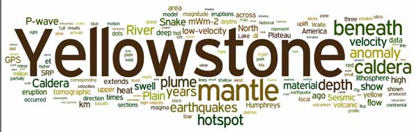
Hotspot is a place in the Upper mantle of the Earth at which hot magma from the Lower mantle upwells to melt through the crust usually in the interior of a tectonic plate to form a volcanic feature.
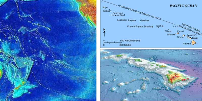
Region of the Earth’s upper mantle that upwells to melt through the crust to form a volcanic feature. Most volcanoes that cannot be ascribed either to a subduction zone or to seafloor spreading at midocean ridges are attributed to hot spots. The 5% of known world volcanoes not closely related to such plate margins (see plate tectonics) are regarded as hot-spot volcanoes. Hawaiian volcanoes are the best examples of this type, occurring near the centre of the northern portion of the Pacific Plate. A chain of extinct volcanoes or volcanic islands (and seamounts), such as the Hawaiian chain, can form over millions of years where a lithospheric plate moves over a hot spot. The active volcanoes all lie at one end of the chain or ridge, and the ages of the islands or the ridge increase with their distance from those sites of volcanic activity.

The surface manifestations of plumes, that is, columns of hot material, that rise from deep in the Earth’s mantle. Hot spots are widely distributed around the Earth. One of their characteristics is an abundance of volcanic activity which persists for long time periods (greater than 1 million years). When the lithosphere (the rigid outer layer of the Earth) moves over a plume, a chain of volcanoes is left behind that progressively increases in age along its length. Hot spots are believed to be fixed with respect to each other and the deep mantle so that the age and orientation of these chains provide information on the absolute motions of the tectonic plates.

Most recently proposed hotspots. Some are parts of “hotlines,” and some are inferred on the basis of age progressions rather than specific volcanic features. Red triangles indicate fifty-one hotspots, black squares volcanoes, black rings hotspots underlain by seismic low-velocity anomalies that extend into the transition zone, yellow rings the plumes proposed on the basis of seismic P-wave velocity tomography, and magenta rings plumes from the core-mantle boundary proposed on the basis of five criteria expected to be associated with plumes. If tectonic context is ignored, these are the strongest plume candidates. ( Anderson, D.L. and Schramm, K.A., 2005, Global Hotspot Maps, in Plates, Plumes & Paradigms, Foulger, G.R., Natland, J.H., Presnall, D.C, and Anderson, D.L., eds., Boulder, CO, Geological Society of America, Special Paper 388, pp. 19-29.)