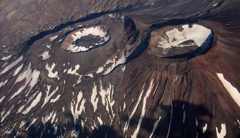
Kilauea Volcano eruptions 2017

KILAUEA VOLCANO 19°25’16” N 155°17’13” W, Summit Elevation 4091 ft (1247 m)
Activity Summary: Kilauea Volcano continues to erupt at its summit and East Rift Zone. Lava continues to enter the ocean at Kamokuna and surface flows remain active within 2.4 km (1.5 mi) of the vent at Puʻu ʻŌʻō. These lava flows currently pose no threat to nearby communities. At the summit, DI deflationary tilt continued and the lava lake surface dropped to about 38 m (125 ft) below the floor of Halemaʻumaʻu crater this morning.
Summit Observations: Summit tiltmeters recorded continuing DI deflation. The lava lake surface dropped along with the tilt and is estimated to be about 38 m (125 ft) below the floor of Halemaʻumaʻu crater this morning. Seismicity rates were at background levels and tremor values fluctuated in response to changing lava lake circulation, spattering, and rockfalls. Sulfur dioxide emission rates ranged from about 4,600 to 5,800 metric tons/day over the past week, when measurements were possible during trade wind conditions.

Cerro Azul VolcanoEruption. Galapagos Islands. 2008

Shield volcano 1640 m / 5,381 ft
Isabela Island, Galapagos Islands (Ecuador), -0.92°S / -91.41°W
Cerro Azul volcano eruptions: 1850, 1932, 1940, 1943, 1948, 1949(?), 1951, 1959, 1968(?), 1979, 1998, 2008

Cerro Azul volcano a basaltic shield volcano on the SW part of Isabela Island in the Galápagos Islands. It has the same name as Cerro Azul volcano in Chile, meaning “Blue Mountain” in Spanish.
Cerro Azul is one of the most active volcanoes of the Galapagos hot spot.

Cerro Azul, 1640 m high and the second highest peak of the Galápagos archipelago, is a typical shield volcano located at the SW tip of Isabela Island. It is one of the most active volcanoes of the Galapagos, although historic records from its activity only dates back to 1932.
As most of the other shield volcanoes on the Galapagos island, it has a steep-walled 4 x 5 km nested summit caldera, one of the smallest diameter, but at 650 m one of the deepest in the Galápagos Islands. Young lava lows cover most of the floor of the caldera, where temporary lava lakes are sometimes present during summit eruptions. Numerous spatter cones from lateral fissure eruptions dot the western flanks of the volcano.

Fernandina Volcano Eruption. Galapagos Islands. 2009.

Shield volcano 1476 m / 4,842 ft
Galápagos Islands, Ecuador, -0.37°S / -91.55°W

Fernandina volcano eruptions: 2009

Fernandina, the most active of Galápagos volcanoes and the one closest to the Galápagos mantle plume, is a basaltic shield volcano with a deep 5 x 6.5 km summit caldera. The volcano displays the classic “overturned soup bowl” profile of Galápagos shield volcanoes. Its caldera is elongated in a NW-SE direction and formed during several episodes of collapse. Circumferential fissures surround the caldera and were instrumental in growth of the volcano. Reporting has been poor in this uninhabited western end of the archipelago, and even a 1981 eruption was not witnessed at the time. In 1968 the caldera floor dropped 350 m following a major explosive eruption. Subsequent eruptions, mostly from vents located on or near the caldera boundary faults, have produced lava flows inside the caldera as well as those in 1995 that reached the coast from a SW-flank vent. Collapse of a nearly 1 cu km section of the east caldera wall during an eruption in 1988 produced a debris-avalanche deposit that covered much of the caldera floor and absorbed the caldera lake.

Wolf Volcano Eruption. Galapagos Islands. 2015.

Shield volcano 1710 m.
Galápagos Islands, Ecuador, 0.02°N / -91.35°W

Wolf volcano eruptions: 2015, 1982, 1797

A 6 x 7 km caldera, at 700 m one of the deepest of the Galápagos Islands, is located at the volcano’s summit. A prominent bench on the west side of the caldera rises 450 above the caldera floor, much of which is covered by a lava flow erupted in 1982.
Radial fissures concentrated along diffuse rift zones extend down the north, NW, and SE flanks, and submarine vents lie beyond the north and NW fissures. Similar unvegetated flows originating from a circumferential chain of spatter and scoria cones on the eastern caldera rim drape the forested flanks of the volcano to the sea. The proportion of aa lava flows at Volcán Wolf exceeds that of other Galápagos volcanoes. Wolf’s 1797 eruption was the first documented historical eruption in the Galápagos Islands.

Etna Volcano Eruptions

Etna’s eruptions have been documented since 1500 BC, when phreatomagmatic eruptions drove people living in the eastern part of the island to migrate to its western end. The volcano has experienced more than 200 eruptions since then, although most are moderately small. Historic eruptions are recorded for the year 479 B.C., 1329, 1381 and 1536, one of the largest and most destructive eruptions was a flank eruption in March to July 1669 from near the village of Nicolosi (800m a.s.l.) which produced the cinder cone Monti Rossi and a 14km long lava flow which, despite it was partially deviated from its path by a artificial dam, destroyed part of the city of Catania, obstructed the harbour and caused victims.
Cinder cones on Etna erupted again in 1763, 1811, 1852, 1865, 1879 and 1892. In the 20th century, concentrated on two main branches extending from the crest, lava erupted in 1908, 1910, 1911, 1918, 1923, 1928, 1942, 1947, 1949 and 1950-1951, 1964, 1968, 1971, 1981, 1983, 1989 and 1991 (the most voluminous eruption since 1669) to 1993.

The activity continues in the 21th century, from 2001 Etna is more or less active (in 2002 and 2003 the volcano produced spectacular ash plumes), weaker since 2008 now the activity increased again since 12 January 2011.

http://www.virtualuppermantle.info/RU/Etna-Stratovolcano-RU.htm

http://www.virtualuppermantle.info/Etna-Stratovolcano.htm

Kavachi Submarine Volcano Eruptions

Kavachi is the most active undersea volcano in the world.
Kavachi submarine volcano -20 m
Solomon Islands, -9.02°S / 157.95°E
Current status: dormant (1 out of 5)
Kavachi volcano is a submarine volcano located south of the remote Vangunu Island in the Solomones. Kavachi volcano is also known as Rejo te Kvachi, “Kavachi’s Oven”. Kavachi volcano with near surface eruptions every few years that often build temporary islands.
Kavachi submarine volcano in different stages. The volcano has emerged and eroded back into the ocean at least ten times since it was first recorded.
How a new island is made by show Mother Nature? Watch the Kavachi undersea volcano as it erupts underwater.


Kavachi volcano eruptions: 2014, 2007, 2004, 1999-2003, 1999 (Feb-May), 1998 (?), 1997, 1991, 1986, 1985, 1982, 1981 (Sep) (?), 1980-81, 1978, 1977 (Jul), 1977 (Feb), 1976, 1975, 1974, 1972, 1969-70, 1966, 1965, 1963-64, 1962, 1961, 1958, 1957, 1952-53, 1951, 1950, 1942, 1939


Merapi stratovolcano 2006, 2010 Eruptions.

Stratovolcano elevation: 2968 m
Central Java, Indonesia: 7.54°S,  110.44°E
Merapi, a steep stratovolcano north of Central Java’s capital Yogyakarta, is Indonesia’s most active volcano. It erupts on average every 5-10 years and is feared for its deadly pyroclastic flows – avalanches of hot rocks and gas that are generated when parts of new lava domes constructed during eruptions in the summit crater collapse and slide down the mountain’s steep flanks.
The name “Merapi” from old Javanese language means “the one making fire” is a popular name for volcanoes: another volcano with the same name Merapi is in the Ijen Massif in East Java and similarly called volcano “Marapi” lies on Sumatra Island.

Kilauea Volcano, Hawaii.

Kilauea is a currently active shield volcano in the Hawaiian Islands, and the most active of the five Hawaiian volcanoes. Kilauea is the most active volcano on the Earth. Located along the southern shore of the island. Coordinates: 19°25’16″N; 155°17’13″W, Summit Elevation: 1247 m. Kilauea’s current eruption dates back to January 3, 1983, and is by far its longest-lived historical period of activity, as well as one of the longest-lived eruptions in the world; as of January 2011, the eruption has produced 3.5 cubic kilometers of lava and resurfaced 123.2 km2 of land. Volcano Kilauea is between 300,000 and 600,000 years old. Volcano emerged above sea level about 100,000 years ago. It is the second youngest product of the Hawaiian hotspot and the current eruptive center of the Hawaiian–Emperor seamount chain. Structurally, Kilauea has a large, fairly recently formed caldera at its summit and two active rift zones, one extending 125 km east and the other 35 km west, as an active fault line of unknown depth moving vertically an average of 2 to 20 mm per year.

Hawaii Kilauea Volcano Eruption&Lava Flow. Video.

Loihi Volcano (Seamount). Hawaii.

Loihi Seamount is an active submarine volcano built on the seafloor south of Kilauea about 35 km from the Hawaii Island. The seamount rises to 969 m below sea level. Loihi is the newest volcano in the Hawaiian-Emperor seamount chain, a string of volcanoes that stretches over 5,800 km northwest of this volcano.
Location: 18.92 N 155.27 W.
Volume: 660 km3.
Like the volcanoes on the Island of Hawaii, Loihi has grown from eruptions along its 31-km-long rift zone that extends northwest and southeast of the caldera.

Loihi volcano (Seamount). Video.